I was taking a walk in a local park recently. The Sydenham river flows through the park and plunges over the Niagara Escarpment creating a local attraction called Inglis Falls. Usually a very pretty sight, but during the spring thaw and following a heavy rainfall, it had become a raging torrent of water that was a sight to behold.
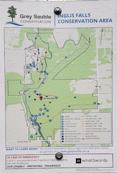
Following one of the trails I came across a new sign erected by conservation area staff. It contained a What 3 Words reference for use in emergency:
DEPLORABLE – IRRITATING – FRAGRANCE
I nearly fell down with laughter at the thought of calling 911 and telling the dispatcher “Deplorable, Irritating, Fragrance”. I can just imagine the response: “I am sorry sir, but a disagreeable smell does not constitute an emergency!” .

The What 3 Words system is gaining popularity in public events where ham radio volunteers attend to provide event communications. This grumpy old ham finds the whole idea “deplorable and irritating” and wonders why the good old Maidenhead Grid Squares system isn’t used instead. Maidenhead Grid Squares are not so easily confused by dialects and mispronunciation. If communication is hampered by background noise – like a roaring waterfall carrying spring meltwater downstream – we have ICAO phonetics to clarify the message.
I once read about a radio message sent by British forces during the Second World War. The message was “Send Reinforcements we’re going to advance” but due to poor propagation conditions it was received as “Send three and fourpence we’re going to a dance” (“Three and fourpence” refers to an old money system used in the UK). The story probably isn’t true, but it illustrates my point.
This prompted me to find out just how the Maidenhead Grid Squares system works. Most hams can probably remember the grid square for their home QTH, but how many really understand how those strange alternating alphanumerics are derived? It took me a while to figure it all out and the explanation is actually quite interesting.
I used the grid square reference for my own home QTH (EN94MO31) as an example. The first figure shows the overall construction of the grid square reference system. It might be a bit difficult to see the detail in this figure, but each element is separated in the other figures below.
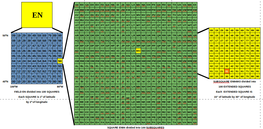
Wikipedia was a great help in working out the basic concept, but I had to use some intuition to figure out the structure of the SQUARES, SUBSQUARES and the EXTENDED SQUARES. I checked my interpretation of the structure by examining the map on F5LEN’s locator site to ensure my QTH is actually where the figures suggest it should be. I believe this analysis is correct but I am open to correction if I am wrong. I thought I was wrong once before, but I was mistaken [smile].
Oh Planet Earth, our home and native land
So let’s start off with the big picture – our home and native land, the Earth. The Earth is divided up into a matrix of 18 divisions of latitude and 18 divisions of longitude. That makes for a grid of 18×18 or 324 FIELDS. The first character represents longitude and the second character represents latitude. Fields are separated by 20 degrees longitude and 10 degrees latitude. My home QTH within field EN encompasses a large area of both Canada and the United States.
Skip to “Inside each field are 100 squares”
Sidenote: It is an interesting fact about the Earth’s geometry that lines of latitude are parallel to each other, but lines of longitude meet at the poles. If you were to stand at the North Pole and face any direction you would always be looking south. You would also get quite cold, and since there is no land at the North Pole, you would be walking on ice that has a tendency to form large unpredictable cracks (called “leads”) and deep crevasses. It would spoil your entire walk if you were to fall into either of those hazards. Of course, there is also the possibility of meeting one of the local inhabitants who stand ten feet tall, weigh up to 2000 pounds, wear thick white coats and are always hungry.
A personal narrative: I was once young and intrepid enough to consider skiing to the North Pole. I inquired about an organized expedition that would meet in Moscow, then be taken by plane and helicopter to a point in the eastern Arctic Ocean 100 kilometers from the pole. We would ski to the pole from that point over the course of the next three days before being picked up by a chartered plane and returned to Moscow. I was seriously interested, but decided not to proceed. I had just recently had my article on decoding Russian military navigation satellite signals published in the United States and considered the possibility that Russian authorities might wish to engage with me about it. There was also the cost: twenty five thousand dollars.
Inside each field are 100 squares
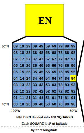
Field EN covers the area from 80 degrees west to 100 degrees west and from 40 degrees north to 50 degrees north. It encompasses a large area in which three of the Great Lakes – Superior, Michigan and Huron – are located. Most of Lake Erie is also within field EN. The boundaries run from just west of the Greater Toronto Area in Canada to Nebraska and the Dakotas in the west and the city of Winnipeg in Canada to the north.
Every field is divided into 100 SQUARES each of which is 2 degrees of longitude by 1 degree of latitude. My own grid square is EN94 which is bounded by 80 and 82 degrees longitude, 44 and 45 degrees latitude and lies entirely within Canada. This is a much smaller area – one that I could drive all the way around in a single day (although perhaps not in a Southern Ontario winter). A significant portion of EN94 is covered by parts of Lake Huron and Georgian Bay (technically part of Lake Huron). This is a more manageable area of the planet’s surface, but still too large to readily locate somebody in an emergency, which is deplorable and perhaps a little irritating.
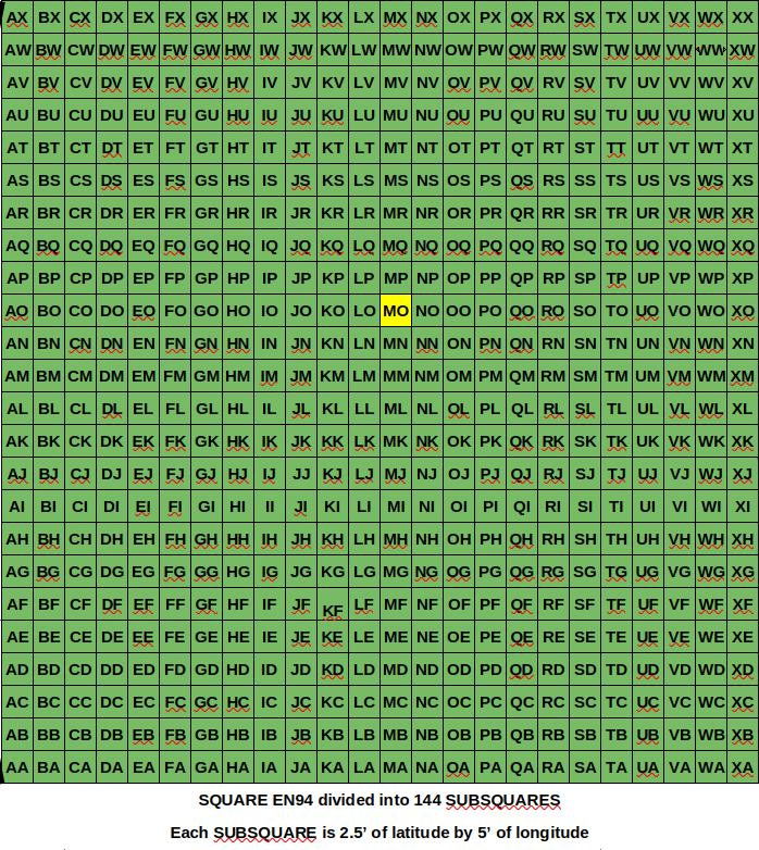
Each Square is divided into 144 Subsquares
But, the Maidenhead Grid Square system is further divided into 144 SUBSQUARES each of which is 5 minutes of longitude east to west and 2.5 minutes of latitude south to north. It should be noted that everything is measured east of the antimeridian of Greenwich and from the South Pole northwards and that dictates the organizational layout of Squares and Subsquares.
My home QTH lies within the Subsquare EN94MO which defines a fairly small area to the northwest of the City of Owen Sound, Ontario and includes the outer harbor of the Port of Owen Sound – not a busy port but we do enjoy the visits of several very large ships each year.
Each Subsquare is further divided into 100 Extended Squares
Subsquare EN94MO includes both urban and rural areas. The rural areas are heavily wooded with some quite challenging and dangerous trails to explore. The Niagara Escarpment runs right through it and there are some precipitous drops over sheer cliff edges as well as numerous wide chasms in the exposed rock of the escarpment. Search and Rescue teams still have quite a challenge to locate a hiker – or itinerant amateur radio operator like myself. Perhaps that is still deplorable, irritating and, close to the lake in the fall, fragrant with the smell of decaying fish during the annual salmon spawning run.
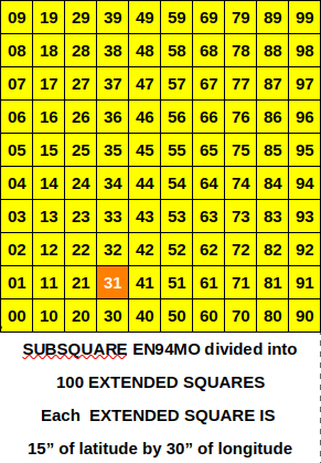
Not to worry though, the Maidenhead Grid Square system still has a few more aces up its sleeve. Each Subsquare is divided into 100 EXTENDED SQUARES each of which is 30 seconds of longitude east to west and 15 seconds of latitude south to north.
My home QTH lies within Extended Square EN94MO31. Now we are down to a very small suburban area in which it would be very easy for emergency services to find me if I should fall off a ladder while rescuing my antennas. Strangely though, emergency services don’t actually use the Maidenhead Grid Square system or the “deplorable, irritating” What 3 Words system. I think they should consider adopting Grid Squares; the road system in the City of Owen Sound can be very confusing with discontinuities in many roads that got me lost many times when I first moved here. Hams would be pleased to work with Emergency Services to explain the benefits of our grid squares system.
The Maidenhead Grid Square system can be infinitely divided into more accurately defined areas using alternating “base 10” and “base 12” definitions. One particular ham radio activity, RaDAR – Rapid Deployment Amateur Radio, calls for exchanging grid square locators down to 10 characters. Generally 4 or 6 character locators are used in ham radio and are useful when mapping contacts made during an activity like Parks on the Air (POTA).
Finally, the location identified by What 3 Words as “Deplorable Irritating Fragrance” is at grid square EN94MM86TD or Echo November Nine Four Mike Mike Eight Six Tango Delta. I know which reference I would prefer to be overheard shouting into a microphone!

Help support HamRadioOutsidetheBox
No “tip-jar”, “buy me a coffee”, Patreon, or Amazon links here. I enjoy my hobby and I enjoy writing about it. If you would like to support this blog please follow/subscribe using the link at the bottom of my home page, or like, comment (links at the bottom of each post), repost or share links to my posts on social media. If you would like to email me directly you will find my email address on my QRZ.com page. Thank you!
The following copyright notice applies to all content on this blog.

This work is licensed under a Creative Commons Attribution-NonCommercial-NoDerivatives 4.0 International License.
Discover more from Ham Radio Outside the Box
Subscribe to get the latest posts sent to your email.

I’m with you on Maidenhead grids over three silly words. Although I can see the value of TSW in use by the public to have a mnemonic to remember the encoding of their current location.
But for communicating location with arbitrary precision Maidenhead is superior. And let’s not leave out GEOREF when considering means to communicate location.
LikeLiked by 1 person